a navigational tool for blind and visually impaired
Ulrika Vejbrink
There are two separate activities going on when walking. The first immediate activity is avoiding obstacles in the environment, the other is navigating the area. Few products can currently help the blind to navigate through an unknown environment.
New technology now makes it possible to create a tool that in every day life can assist blind people to find their way.
The purpose of this project is therefore to look into the area of outdoor orientation and navigation for blind and visually impaired people, to make a hi-tech navigational tool that is based on satellitenavigation and that provides the user with the information wanted and needed to simplify the daily problem of navigating.
Functions
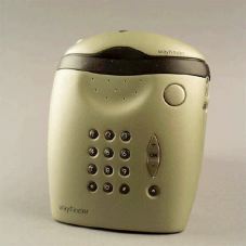
The WayFinder is a personal device to bring along when going out. At any point during a walk outdoors, the user can ask the WayFinder to tell the precise location. The received information is if possible in forms of an exact address, if not, (e. g. on the countryside, far from houses) The position is described by distance to an address or another defined location. The information is delivered by speech.
By pointing the remote control in a certain direction and pushing the arrow shaped button in the front, the user asks the WayFinder to describe the close surroundings. This means getting information about nearby objects like buildings, parking lots, telephone boots etc, whichis useful both in order to build up ones mental picture of the surrounding but also to navigate from, if the user has visual memories or a verbal description of the route to navigate from.
The WayFinder can also describe the route to a certain place. This means that the user beforehand can evaluate the effort and time needed to get to a place and decide upon a suitable means of getting there. The place can be described as an address or with the name of a shop, as a streetcrossing or as an own pre-loaded short name (e. g. the name of the person that lives in the house).
Furthermore, the user can ask the WayFinder for guidance to the location. This means that the tool can give real time advice on the direction of travel at every point of the chosen route. This information can be presented either trough speech or in a tactile manner.
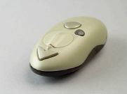 |
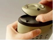
| All controls that are needed when navigating are placed on the remote control |
If the user needs assistance, there is an alarm button on the WayFinder. Pressing it means establishing a GSM line to a service centre where the personnel can view the exact position of the user and give advice or send help. The position of the user can only be viewed when the alarm button has been pressed. A mobile phone is built into the WayFinder and it is used as an ordinary cellular phone.
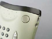 |
| The alarm button is placed on the front of the main unit. |
Handling
How a product is used and carried varies greatly from situation to situation and from user to user. Therefore handling of the WayFinder has to be flexible.
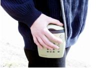
The product consists of three parts; the main unit, the remote control and the antenna. All the functions that are used while navigating are integrated in the remote control. The remote control is a small cordless unit which fits into the palm of the hand. It sits on top of the main unit as they can snap together and function as one unit or they can be taken apart and used separately.
The main unit can be carried in a shoulder strap or at the belt. Both ways the user can choose whether to hold the remote control in the hand or let it stay on the main unit and put the hand on top. He or she can also choose to rely only on sound. The main unit can also be put in a bag or backpack, in which case it should be fastened inside the bad e. g. with the belt clip. It is important that the remote control, which contains the compass, does not move much in relation to the user.
When the user wears the WayFinder as a shoulder bag, the antenna, which should be placed high up, fits into a circular hole in the shoulder strap. The cord is pushed into a groove in the strap. This way the antenna is totally integrated into the product and not a loose part.
 |
 |
| The WayFinder carried on the belt |
 |
| The WayFinder used as a shoulderbag |
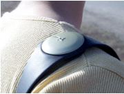 |
| Shoulderstrap with integrated antenna |
Having the right size and a comfortable shape for the hand to hold is crucial for the remote control. It has rounded shapes, without edges that could be disturbing while holding it. At the sides of the remote control there are indents for a good grip when taking it apart from the main unit. The controls are placed in the top where they are easy to reach with the thumb and the bottom part is made of the soft plastic to give a good grip and a nice tactile contrast between the two surfaces. The same materials are used in the main unit.
 |
How it works
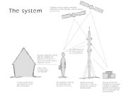
Every user has a personal WayFinder. The GPS signals are sent out from the navigational satellites and are received by the hand-held unit. They are also received by a number of reference stations which measures interferences using their own known position. The reference stations send via the FM net a correcting signal containing the size of the interferences to the hand-held unit (DGPS). Digital maps rare distributed via internet on the GSM net, which also is used for sending alarm messages.
 |